Introduction
In the mobile internet era, the smartphone has become a standard part of daily life. Smartphones host a wide variety of apps that provide many services, including location services. Every person and object on Earth has spatial location information; locating that position is essential for finding people or items.
Historical Context
Maps have been used since the early days of civilization to indicate locations. As navigation tools such as the compass and sextant were developed, human ability to locate position improved in accuracy and reliability.
Outdoor Positioning: Satellite Navigation
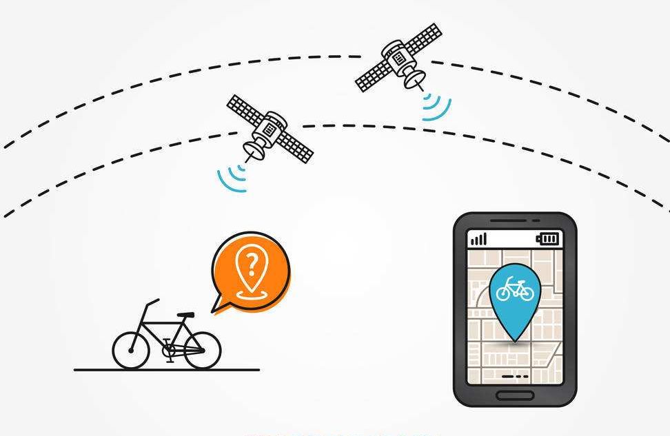
Outdoor positioning is most commonly achieved with satellite navigation. Satellite positioning uses artificial Earth satellites for point measurement and is widely used because it provides high accuracy, fast fixes, and low user-side cost.
Only a few countries have the capability to build and operate global navigation satellite systems. Well-known systems include the US GPS, China's BeiDou (BDS), Europe's Galileo, and Russia's GLONASS. Japan operates the QZSS regional augmentation, and India operates IRNSS.
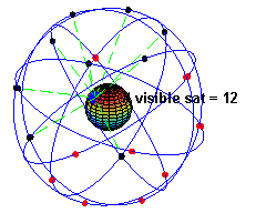
Taking the US GPS as an example: GPS stands for Global Positioning System. Its origins trace back to a US military project starting in 1958, with initial deployment in 1964 and full constellation deployment completed by 1994. The GPS constellation consists of 24 satellites, 21 operational and 3 on-orbit spares, arranged in 6 orbital planes at an altitude of 20,200 km with an orbital period of about 11 hours 58 minutes. At any given time and place on Earth, an average of six GPS satellites can be observed simultaneously, with up to ten available in optimal conditions.
Satellite systems also require ground monitoring infrastructure. For GPS, the ground control segment includes a master control station, several monitor stations, and uplink stations to track, maintain, and upload navigation data to the satellites.
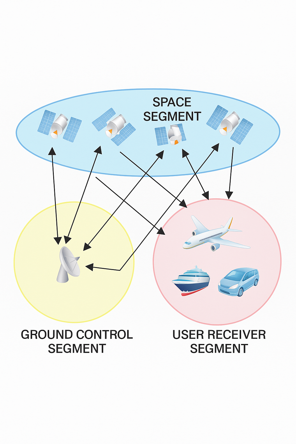
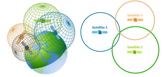
The basic principle of satellite navigation is to measure the distance from satellites with known positions to the user receiver. By combining measurements from multiple satellites, the receiver computes its position.
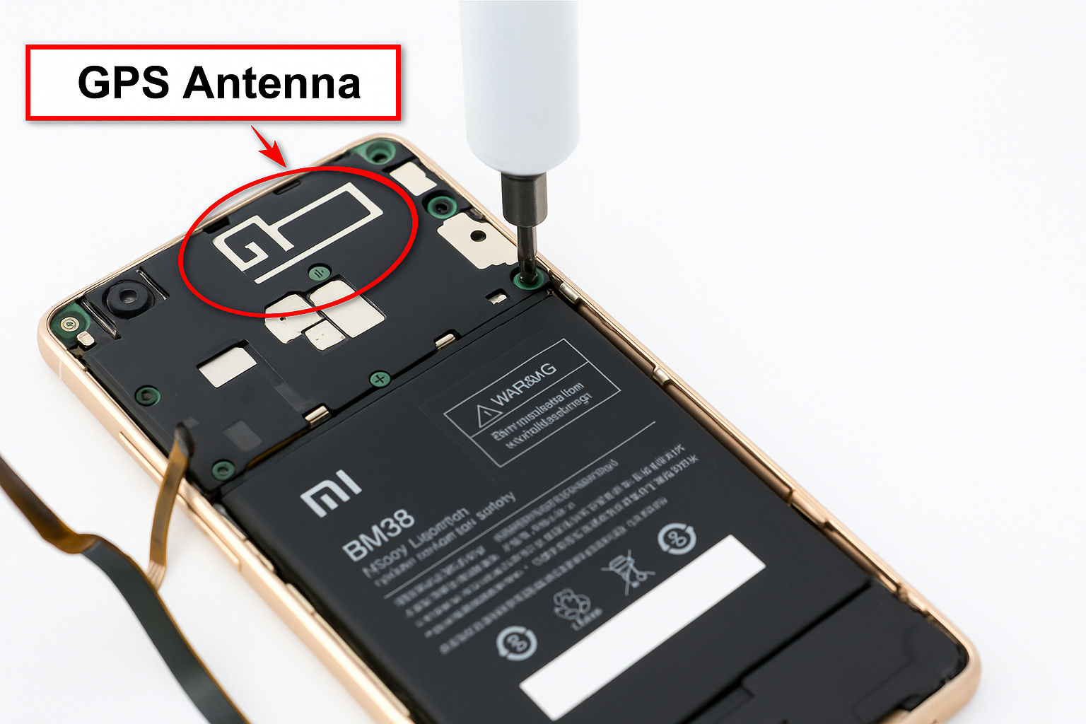
Smartphones include a GPS chipset and an antenna and act as the receiver that acquires and processes satellite signals. The location data is then used by the operating system or apps to provide positioning services.
Note: Satellite positioning can be affected by the ionosphere, which contains charged particles that distort radio signals, and by multipath effects caused by signal reflections. Under clear conditions, GPS accuracy is generally good.
Because of national security considerations, countries often develop their own systems. For example, China developed the BeiDou system. China's BeiDou system has reached commercial capability and, when used with reference stations, can provide positioning accuracy comparable to GPS, on the order of 10 meters. BeiDou also supports short message capability, addressing a limitation of strictly broadcast-only GNSS systems.
Outdoor Positioning: Base Station (Cellular) Methods
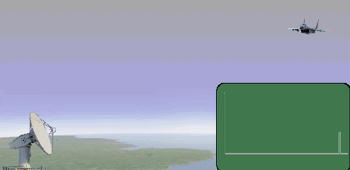
Another common outdoor positioning approach uses cellular base stations. Conceptually, a base station can be treated like a radar transmitter. In urban areas a smartphone is typically within range of multiple cell towers. The phone measures downlink pilot signals from different base stations to obtain TOA (time of arrival) or TDOA (time difference of arrival) data. Combining these measurements with known base station coordinates enables computation of the phone's position via trilateration.
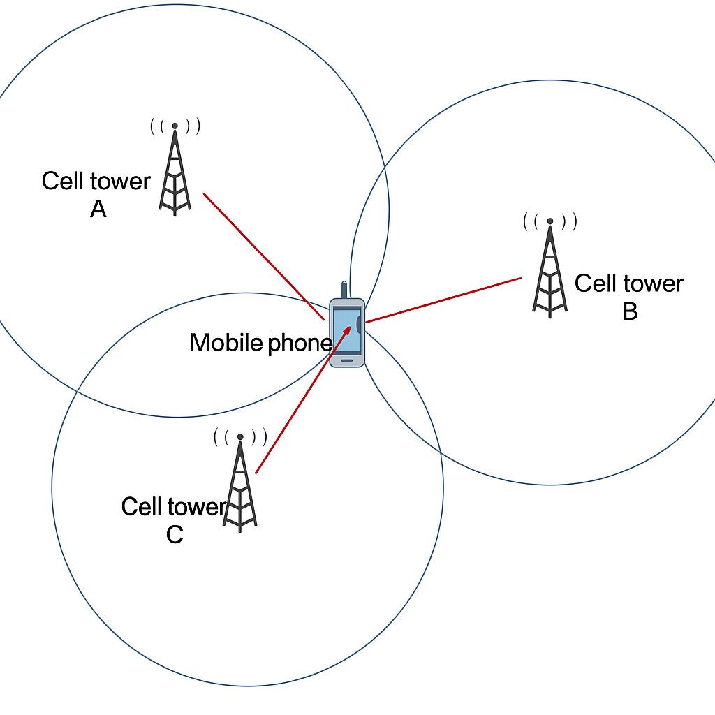
Cellular positioning accuracy is generally lower than GNSS, typically on the order of hundreds of meters to kilometers. Accuracy depends on the number, density, and geographic precision of base stations. Rural areas with sparse base station coverage yield much lower accuracy.
It is possible to retrieve the identifier of the cell serving a handset for a coarse location estimate. For example, diagnostic codes on some devices can display current cell information. This approach is fast but coarse, since a cell can cover a large area.
Wi-Fi Positioning
Wi-Fi can also be used for positioning, but this is different from IP-based geolocation. Each Wi-Fi access point has a unique MAC address and typically remains stationary. When a scanning device detects nearby APs, it can record their MAC addresses and signal strengths and upload this information to a positioning server. Over time, servers build a database mapping AP MAC addresses to geographic coordinates.
AP location data can be collected actively (for example, by vehicles that record Wi-Fi signals alongside GPS coordinates) or via user-submitted data when users agree to location-data collection. When a device sends its observed AP list to a location service, the server returns a calculated position based on AP locations and signal strengths, similar to trilateration.
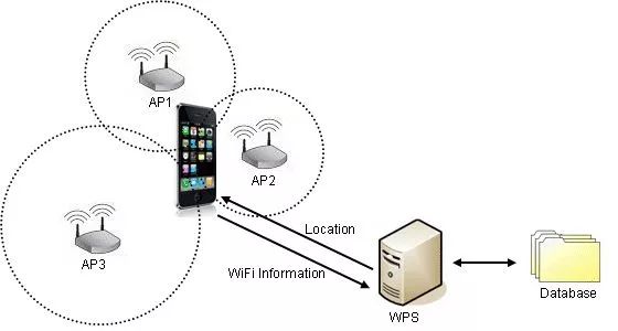
Wi-Fi positioning works best in environments with dense AP coverage. It is commonly used as a supplement to GNSS and cellular methods rather than as a primary method in wide-area positioning.
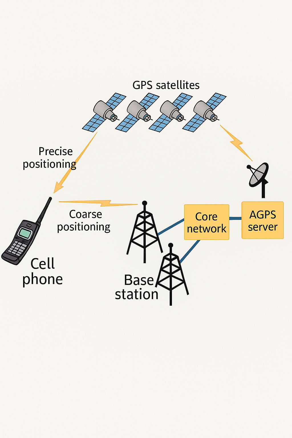
A-GPS (Assisted GPS)
A-GPS combines GNSS with network-based assistance to accelerate satellite acquisition. The handset obtains a coarse location from the cellular network and requests from an A-GPS server the satellite ephemeris and other parameters relevant to the estimated region. With this assistance, the receiver can search for satellites and compute a fix much faster, often in a matter of seconds.
Indoor Positioning
GNSS signals do not penetrate buildings well, so indoor positioning requires alternative approaches. Typical indoor positioning requirements include finding parked vehicles in underground garages, locating people in large shopping centers, industrial asset tracking, and indoor IoT device localization.
Any short-range communication technology can be used for indoor positioning by measuring signal properties such as time of flight, signal strength, or fingerprint signatures. Common indoor technologies include Bluetooth, infrared, RFID, ultrasound, Zigbee, and UWB.
Bluetooth Positioning
Bluetooth positioning deploys small beacons across a region. These beacons broadcast signals that mobile devices can detect. By installing beacons every few meters and measuring signal strength or using proximity detection, systems can determine a device's location. Bluetooth-based approaches, including Apple's iBeacon protocol introduced in 2013, offer low-power micro-location capabilities that are easy to integrate into mobile devices.
UWB (Ultra-Wideband)
UWB positioning uses a network of anchors with known positions to communicate with a device (blind node) and determine its location through ranging or fingerprinting. UWB transmits very short pulses with GHz-level bandwidth, enabling precise time-of-flight measurement. UWB offers strong multipath resistance, good penetration, high security, and high positioning accuracy, making it attractive for many indoor applications.
Other indoor methods exist, but are omitted here for brevity.
Privacy and Security
Location data is sensitive personal information. It must not be collected illegally or used for unlawful purposes. Users should protect their location data and avoid granting location permissions to untrusted apps to reduce privacy and safety risks.